Introduction
The site selection process of the CHDU project requires estimates of annual heat demand for domestic and non-domestic properties. This article discusses the different data sources which have been considered and used to create the heat demand map layers used in the site searching process, and presented in the interactive map.
Potential Sources of Heat Demand Data
Thermos
The THERMOS software is a user-friendly, free and open-source software to make heat network planning faster, more efficient, and more cost effective. A core function of the software is to optimise heat network routing between buildings and optimise heat supply and demand, requiring THERMOS to include a model which estimates the annual thermal demand of individual buildings.
The THERMOS space heating estimation model, defined in the software help documentation, used four regression models trained using building properties and demand data in Copenhagen, including: footprint, usage and height, validated against measured space heating data in the UK. The models predict urban space heating demand data well but are less successful at predicting demand in rural areas. Underprediction of demand in rural areas is perhaps due to agricultural buildings using less heat than their roof size suggests, and buildings having their heat demand met by unmetered fuels such as oil or LPG.
The space heating models are available in the THERMOS source code but are not available as a UK wide dataset so would have to be combined with building shape and location data to create a national map layer for use in a site search. Within the software, space heating demand is calculated using building data from OpenStreetMap when the user selects a map region to model.
The THERMOS software predicts hot water usage using SAP 2012.
Hotmaps
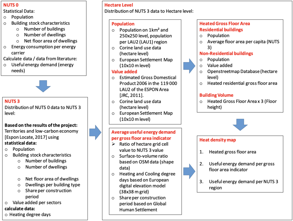
The overarching goal of Hotmaps is the development of an open source heating/cooling mapping and planning toolbox and to provide default data for EU28 at national and local level. As a GIS based online software, Hotmaps includes map layers which estimate the heating demand of residential and non-residential buildings (space heating and hot water) within hectare squares in the EU, including the UK. This data is accessible through the online map interface, or as downloadable GIS compatible datasets (values are MWh/ha/annum).
The methodology for calculating the space heating and hot water demand is documented alongside the downloadable datasets and accompanying report (section 2.1.3) and paper. The methodology uses a “top-down” approach incorporating the following hectare level data:
- Population.
- Building construction age.
- Heating degree days.
- Statistics of energy demand per floor area.
- Floor area per capita (residential).
- OpenStreetMap building area (non-residential).
- Building volume (based on number of floors).
The methodology is outlined in the following schematic:
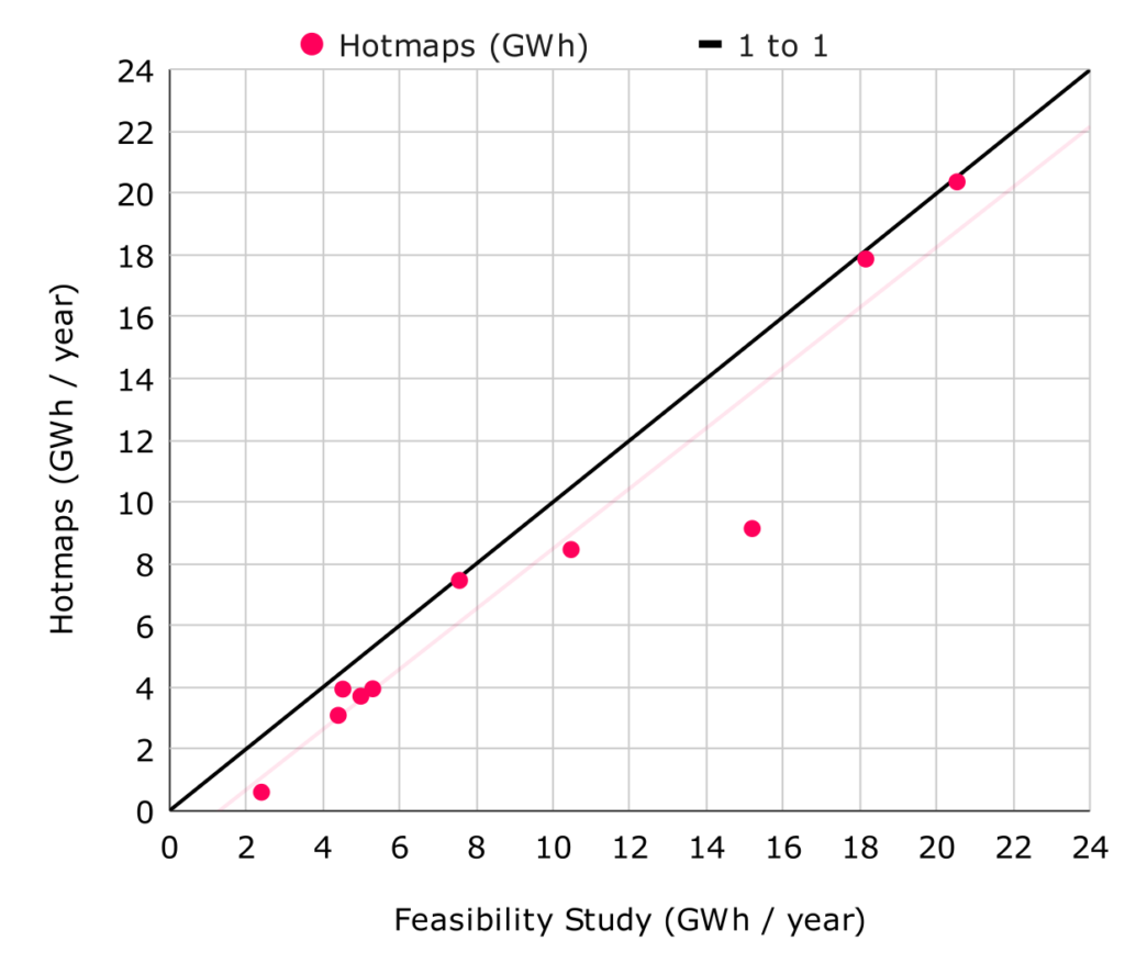
A limited review of the estimated thermal demand reported in the Hotmaps dataset has been completed by comparing demand values against those reported in 10 community-led feasibility studies in the UK. The figure below compares the Hotmaps annual thermal demand against the reported values. The Hotmaps dataset consistently underestimates the annual thermal demand. It normally underestimates thermal demand with an average of ~25% compared to the reported values.
Pan European Thermal Atlas
The Pan-European Thermal Atlas is a EU project which produced an online interactive GIS mapping platform and GIS format open dataset containing estimates of:
- Building heat demand at hectare level (residential and service sector).
- Non-industrial heat sources.
- Industrial heat sources and demands.
- Transport energy demands.
- District heating capital costs.
- Local district heating potentials.
An initial review of the building heat demand (based on 2015 data) suggests that there may be greater coverage in the UK compared to the Hotmaps dataset, however direct comparison is harder due to the online viewer not enabling calculation of heat demand aggregated across a selected area.
DECC CHP Development Map
The UK CHP Development Map presents 1km square tiles of heat demand across the UK. There is also functionality to define custom areas and generate tabulated heat demand data where demand is categorised by sector e.g. domestic, education, small industrial.
This source was discounted since the resolution is too coarse for our purposes (we’re aiming for 1ha areas) and we were unable to acquire the underlying dataset for use in our site search process.
Energy Performance Certificates (EPCs)
The primary source of building energy usage data in the UK is EPC certificates however there are a number of limitations:
- EPC data data is known to overestimate the heat demand of properties. A study of gas consumption data in the UK suggests that the metered gas consumption, and hence heat demand, is almost always within the range estimated for EPC band C.
- EPC data is only available for 60% of domestic properties in England and 55% in Wales (gov.uk) so a national mapping exercise would need to interpolate data across missing properties.
- Bulk downloads of EPC data for England and Wales available at https://epc.opendatacommunities.org/ do not include the heat demand estimates which are present in online or paper EPCs. It is not clear how heat demand can be calculated from the limited information in the bulk download. Note that bulk downloadable EPC data in Scotland does include heat demand estimates.
Given the above limitations it is not feasible to use EPC data to generation nationwide maps of heat demand density for use in the CHDU site searching exercise.
Non-domestic Display Energy Certificates (DECs)
Display Energy Certificates are similar to EPCs however they are only required for non-domestic buildings with a floor area greater than 250m2 that are occupied by a public authority or provide a public service. DECs are issued each year and contain kWh values of the actual fuel usage to meet the annual heating demand of the building.
DEC data is available in bulk downloadable format from https://epc.opendatacommunities.org/ for England and Wales.
Sources Used in CHDU Site Selection: Hotmaps and DEC Data
Based on the above information, the following datasets are used to estimate building heat demand data during the CHDU site searching process:
- Domestic demand: Hotmaps domestic dataset due to its availability at a 1ha level and reasonable correlation against domestic EPC data reported in the reviewed heat network feasibility studies.
- Non-domestic demand: Combination of Hotmaps non-domestic dataset and DEC data. DEC data is used when available for buildings within a 1ha area, else the Hotmaps non-domestic data is used.
Note that the CHDU site searching process reduces the heat demand density of domestic buildings by 50% to represent a 50% uptake of heat network connections within an area.