Introduction
Heat networks typically require kilometres of pipework to transport heat to and from the network’s Energy Centre and connected customers. The pipework and trenching operations required to install it are one of the most expensive aspects of a heat network, therefore accurately estimating the cost of the pipework is essential to determining whether a heat network is likely to be financially viable.
Network length would typically be assessed at a specific heat network site using heat network optimisation software such as THERMOS. THERMOS is a web-based software developed by the Centre for Sustainable Energy to enable the planning of heat networks and uses address-level mapping to estimate optimised network layouts, including details of pipework dimensions and lengths required to connect requested buildings. Since the CHDU techno-economic model is being used to assess the high level feasibility of sites across mainland GB without any knowledge of local road layouts and without identification of specific connected buildings, a generalised approach to estimating network length has been developed.
Estimating Network Length
In any heat network, the length of the required pipework will be determined to a large extent by both the size of the network (in terms of the area that it supplies) and the number of buildings to which the network supplies heat. A heat network covering the same area but twice as many houses as another heat network (i.e. higher building density) will use more pipe. Similarly, a heat network that connects the same number of buildings but over a wider area (i.e. higher network area) will also use more pipe.
Using 16 THERMOS simulations provided by Carbon Alternatives we have investigated the relationship between building density and network area to predict network length. These simulations incorporated a range of housing archetypes and non-domestic buildings at urban and rural locations across the UK. The network length and the number of buildings were extracted from each THERMOS simulation and the approximate network area was estimated by drawing a bounding polygon around the network in Google Earth.
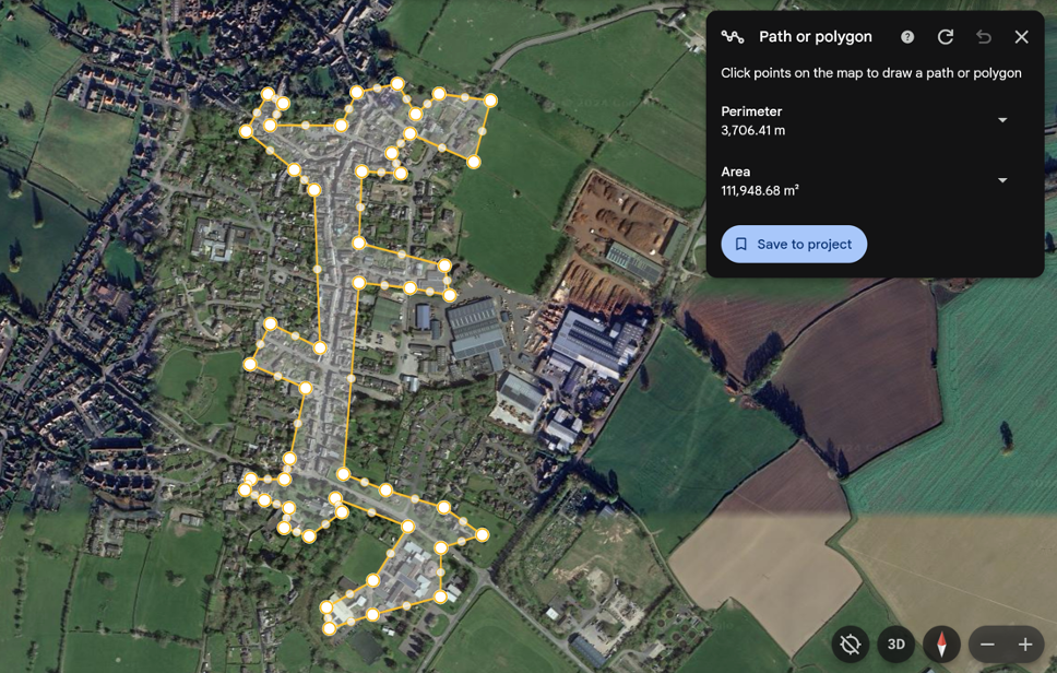
Building density was calculated by dividing the number of buildings connected to the network by the area of the network in hectares. The network length per connected building was calculated by dividing the network length calculated by THERMOS by the number of buildings in the network. The relationship between the network length per connected building and connected building density is presented below. Networks connecting high density terraced housing are represented by points to the right-hand side of the graph and networks of lower density detached housing or non-domestic buildings (industrial estates) occupy the left-hand side.
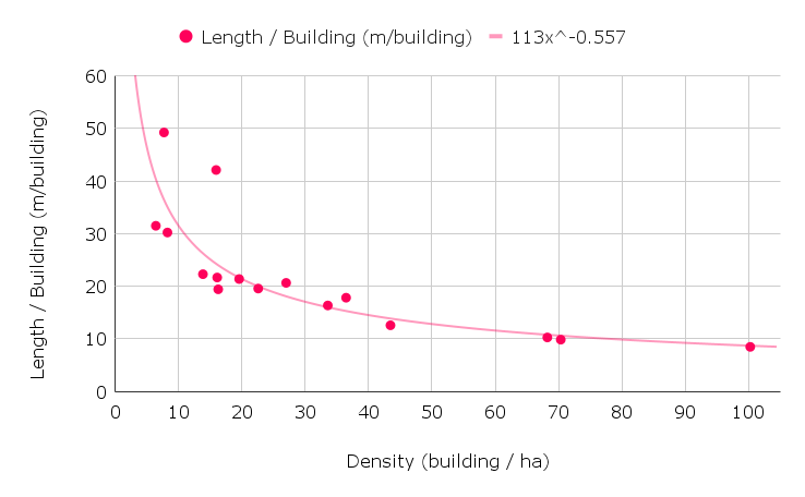
There is a clear relationship between network length and building density which can be approximated using the formula y = 113 x-0.557 where x is building density and y is network length per building. This curve fit generally slightly overestimates the network length for a given building density, which is conservative. This relationship is built into the CHDU techno-economic model enabling network length to be estimated from building density and network area, both of which are spatially derived values which can be used in a nationwide search for feasible heat network locations.
How Network Length is Used
The CHDU techno-economic model uses network length to calculate:
- Pipework costs. The length and distribution of different pipework sizes within a heat network affects the cost of purchasing and installing pipework.
- Network heat losses. Heat is lost through the pipework due to the temperature difference between the coolant and the ground, and the thermal conductivity of the pipework insulation. Network length and pipework sizes affect the network heat losses, for a given flow/return temperature.
The different uses of network length are discussed in more detail in other articles on this site.
References
Google Earth, https://earth.google.com/web/
THERMOS, https://www.thermos-project.eu/home/
Banner Image Attribution:
Image sourced from commons.wikimedia.org and licensed under the Creative Commons Attribution-Share Alike 3.0 International license.